| Photos - Videos - Sounds - Rates - Availability - For whom is this villa? - Make reservation - Home |
| You are here: Driving directions to the Jungle Villa from San Jose International Airport (SJO) |
| 1. Our exact location on Google Maps | 4. Jungle Villa location on Google Maps |
| 2. Driving directions to the Jungle Villa (See below) | 5. Program your Garmin GPS with our GPS coordinates |
| 3. Aerial view Jungle Villa + surrounding hotels | 6. Save these images to your mobile device to find us easily |
|
Distance Time |
Description of your trip San Jose airport to Quepos and Manuel Antonio (Jungle Villa) |
|
0 km 00.00 |
San Jose International Airport Departure If you rent your car right at the airport, take the first exit to Alejuela (exit to the right; this road doubles back) then stay in left lane to San Ramon; DON'T take the second exit to the right that says Alejuela. Now follow the Panamerican Highway (Costa Rica 1) in the direction of San Ramon / Puntarenas |
|
10 km 00.12 |
Take exit to Atenas / Punta Leona
This is Point 4 on the map at the bottom of this page Exit right then turn left on Highway 3 (going over the Panamerican Highway) You will follow this road for the next 1 hour or so If you want to follow Highway 27 (faster, toll-road) you should turn left at Road 136 after 3.3 km from the Panamerican Highway (check odometer) This is Point 3 on the map at the bottom Follow Road 136 for 4.2 km, then take the ramp at the left BEFORE Highway 27 At the top of this ramp you make a sharp U-turn to the right and take the ramp to Highway 27 Follow these instructions if you continue to follow the more scenic Highway 3: Now starts your drive over the mountains. There are many curves and one-lane bridges along this road. Every day accidents are happening on this road, please drive very carefully! Don't pass any regular cars, just the very slow traffic. |
| 00.35 |
Atenas center In the heart of Atenas you find the only gas station and a supermarket next to it. The first 15 minutes from here it's still a quite straight road; but then you get around 86 curves within 20 minutes. Passing other cars on this road is dangerous and makes little sense if you want to arrive in one piece.... The road over the mountains is almost finished once you crossed four one-lane bridges |
|
43 km 01.10 |
San Mateo Congratulations, you survived the road over the mountains. Before you reach San Mateo, you will see the sign 'Manuel Antonio 111km' Soon after that sign the road will turn right (straight ahead you'll see a sign that says 'No Hay Paso') Follow the curve to the RIGHT for 1 block and turn LEFT at the next block; now you drive between a church (left) and the San Mateo city park (right) Once you get to the end of San Mateo you'll see another sign that says 115km to Manuel Antonio! |
|
51 km 01.20 |
Orotina Here you are around halfway San Jose and Manuel Antonio, not in distance but in time. In this 'oasis' you find many restaurants, fruit shops, bathrooms and a gas station. You also find here one of the two trafficlights on this trip |
|
51.5 km 01.21 |
End of Orotina, exit to the right 500 meters past the Orotina trafficlight is a turn off to the right. Follow the sign to Quepos / Manuel Antonio / Jaco Now you follow Highway 27 (toll-road) for about 10 minutes After the toll-booth, please stay in the right-hand lane |
|
58.5 km 01.30 |
Exit to the right From here it's around 100 km to Quepos Another turn off - again just follow signs to Quepos / Manuel Antonio / Jaco Soon you drive over a great road where many drivers want to drive too fast and where Costa Rica traffic police is having speed checks most hours of the day! Most drivers from the opposite direction will warn you with their lights when you can expect a speed check over the next few kilometers... |
|
69 km 01.40 |
Crocodile bridge A long two-lane brige is called 'Crocodile bridge'. Stop BEFORE the bridge at the Crocodile Bridge restaurant, lock your car, and walk to the center. You're guaranteed to see some huge (15 foot long) crocodiles below you! |
|
76 km 01.45 |
Pacific Ocean After passing the Nativa resort at the right you reach Steve and Lisa's restaurant. It's the first place where you can touch the Pacific Ocean. You can eat here but from here it's only 10 minutes to the Plaza Herradura Shopping Mall which has several restaurants |
|
91 km 01.55 |
Plaza Herradura Shopping Mall and Restaurants After passing Punta Leona at the right you reach the Los Suenos Marriott Hotel exit in Herradura at the right-hand side At the corner you find the Plaza Herradura Shopping Mall with Auto Mercado supermarket and several restaurants The Auto Mercado is a popular supermarket to shop before continuing to Quepos. It has a great selection of imported 'Western' food, much better than any shop in Quepos or Manuel Antonio. Since it's still 75 minutes to Quepos from here you shouldn't buy here any goods which have to stay cool (meat, ice, etc) |
|
94 km 02.00 |
Jaco After the Los Suenos exit in Herradura, you reach the second and last trafficlight on this trip. It's there for the Jaco school crosswalk so unless there are children in school, it'll be green. |
|
98 km 02.05 |
End of Jaco After driving thru the outskirts of Jaco the road follows a wide uphill curve to the right. Here you find a viewing point overlooking Jaco and Jaco Bay. Once you pass this point the road turns to the left and Jaco is gone! From here it will be 1 more hour to Quepos / Manuel Antonio |
|
100 km 02.07 |
Watching the waves and surfing Before the road goes down again to the 'hippy' center of Playa Hermosa, you will see at a certain point the coastline south of you for up to 15 kilometers. Great view! The next 30 km you will find regularly (un)paved roads at your right hand side to the many, quiet and beautiful beaches along the Pacific Ocean |
|
137 km 02.30 |
Parrita Railroad Bridge Once you pass thru Parrita, you cross the 2-lane Parrita river bridge At the left you still see the old one-lane Parrita Railroad Bridge. This is a prime example of what the bridges in this area used to be: old railroad bridges using tracks horizontally as the driving surface. |
|
Parrita - Paquita road 20 November 2004 there was a 6.2 earthquake centered between Quepos and Parrita. At some places you will notice cracks in the road which are regularly filled. Please drive carefully here. When you come to a part in the road that is sometimes gravel, sometimes asphalt (about 1km in length) you will be driving over the fault line. |
|
|
157 km 02.50 |
Paquita Railroad Bridge 500 Meters past the Paquita gas station (one of the three gas stations in Quepos area) you cross the 2-lane Paquita river bridge At the left you still see the old one-lane Paquita Railroad Bridge. 1 Kilometer after this bridge you reach the 'Collegio de Quepos' which is at the outskirts of Quepos. Keep right and leave the 'Collegio' at your left. |
|
162 km 03.00 |
Quepos 400 Meters past the 'Collegio de Quepos' you pass the second Quepos gas station at the left. From this gas station it's another 1km to the last one-lane bridge, then you enter Quepos center. When you enter the town of Quepos, drive slightly left and down the small incline to the main road (the road that goes straight and at the same height of the road is a foot/bike path). Pass the Best Western Hotel Kamuk on the left. On the third street after Hotel Kamuk, immediately after a small park, is a sign for Manuel Antonio Parque 7km with an arrow pointing left. Take this road. Look at your odometer (or reset it to 0) |
|
166.3 km 03.10 |
Jungle Villa, Manuel Antonio Around 4km from Quepos you see the car rental companies in a building at the LEFT. At the RIGHT you see the Barba Roja Restaurant, Karolas restaurant, then an road going to the Mariposa Hotel and Parador Hotel Stay on the main road direction Manuel Antonio Park and beach and slow down now... At your RIGHT you see Remax Realty, Banco Promerica, Pura Vida supermarket, Coldwell Banker, Agua Azul restaurant After 40 meters (exactly 4.3 km from Quepos) is at the LEFT the Byblos hotel and Byblos Pizzeria. Opposite the Pizzeria (at your LEFT) you enter at the RIGHT the small road that turns almost 360 degrees and you will almost hit the green wall surrounding our 2.3-acre property. After 20 meters you can park at the LEFT in our private covered parking. 20 Meters downhill from our private covered parking you see at the LEFT our green gate which gives access to the Jungle Villa. In the middle of the gate you find a small lightgreen door which you can open from the inside. If this door is closed, please ring the bell at the right pole and our staff will come to open the door. From the gate you walk 50 meters over the jungle bridge to reach the Jungle Villa Welcome Home! |
|
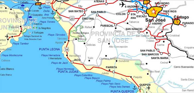
Below you see the road from San Jose airport (plane-sign at the right of Atenas at the top) to Quepos (bottom) From the airport you drive to Quepos via Atenas - San Mateo - Orotina - Jaco - Parrita - Paquita The map below is part of this map (Right-click on map to zoom in or zoom out) Make a print of this page for your convenience Printer-friendly version of this map (portrait-size) |
Printer-friendly version of this map (opens in new Window)
